Flood & Elevation Tool
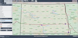
North Dakota Risk Assessment Map Service
The ND Water Commission has released an online flood map data viewer, North Dakota Risk Assessment Map Service.
To access the viewer: ndram.swc.nd.gov
It uses "base level engineering" that combines elevation data with advancements in modeling technology to provide information beyond what appears on standard Federal Emergency Management Agency (FEMA) flood insurance rate maps.
This tool, designed by the Water Commission, provides a user-friendly format; users can:
- Enter a specific address
- Toggle between the base level engineering data and the standard flood insurance rate map data
- View water surface elevations and flood depths
- Download data
- Print customized maps
- Display current radar and weather warnings.
Contact Us
Burleigh County Emergency Management
4200 Coleman St
Bismarck, ND 58503
Phone: (701) 222-6727
E-mail


