Gages
National Weather Service (Bismarck Office)
National Weather Service Website
River Observations
Apple Creek near Menoken
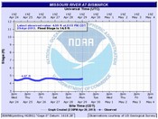
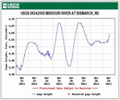
Missouri River at Bismarck
Missouri River below Mandan
USGS WaterAlert
The U.S. Geological Survey WaterAlert service sends e-mail or text messages when certain parameters measured by a USGS data-collection station exceed user-definable thresholds. The development and maintenance of the WaterAlert system is supported by USGS and its data-collection partners, including numerous federal, state, and local agencies.
Real-time data from USGS gages are transmitted via satellite or other telemetry to USGS offices at various intervals; in most cases, once every 1 or 4 hours. Emergency transmissions, such as during floods, may be more frequent. Notifications will be based on the data received at these site-dependent intervals
Sign up here.
US Army Corps of Engineers (Omaha District):
Garrison Dam Release Schedule: Current Regulation Forecast
Missouri River Basin Daily River Bulletin
Missouri River Basin Mainstem and Tributary Reservoir Bulletin
Missouri River Basin Weekly Update
Current Water Resources Information (Fort Peck, Garrison, Oahe, Big Bend, Fort Randall, Gavins Point)
Missouri River Basin Forecast Information
News Releases (Omaha District)
News Releases (Northwestern Division)
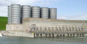
Garrison Dam on the Missouri River near Pick City, ND
Burleigh County Water Gaging Stations
The Burleigh County Highway Department has 14 Water Gaging Stations being monitored by employees, law enforcement and local residents.
**The water gage measurements are only to be used as an indicator of rising or falling water levels. They are not to be used as actual flood levels.
Contact Us
Burleigh County Emergency Management
4200 Coleman St
Bismarck, ND 58503
Phone: (701) 222-6727
E-mail


